How many times have we arrived at a mall or an airport and did not know where to go to find the store that interests us, the checkpoints or the terminal? Many times I have been put in the situation where I have been looking for good minutes for the way to the boarding gate or to a store inside an airport or mall.
A feature for Apple Maps Al iOS 11, which has not been talked about much and which is currently not available for all users, tries to solve this problem. In the application Apple Maps will be available maps of the inside of malls and airports around the world. So if you are in one of the locations present in Apple Maps (indoor maps - Indoor Maps), you can guide yourself very easily using the application.
In order for interior maps to be available to users, each mall and airport will have to allow mapping inside buildings or service areas.
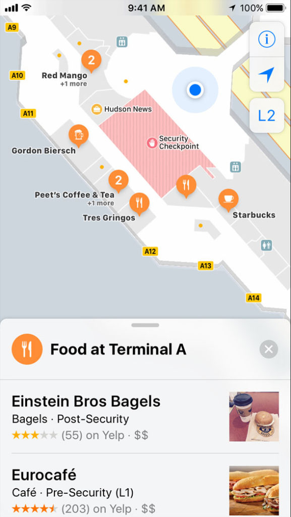
At the moment I am 34 airports around the world that supports Interior mapping and which have already arrived on the Apple Maps service. On these maps you are allowed to quickly see where it is security checkpoints, terminals, areas with restaurants and magazine, plus other objectives of interest for transit trips.
List of airports around the world that have indoor mapping:
Amsterdam Airport Schiphol (AMS)
Baltimore/Washington International Thurgood Marshall Airport BWI
Berlin Tegel Airport TXL
Berlin Schönefeld Airport SXF
Chicago O'hare International Airport ORD
MDW Chicago Midway International Airport
Denver International Airport DEN
Detroit Metropolitan Wayne County Airport DTW
Edmonton International Airport YEG
Geneva Airport GVA
Hong Kong International Airport HKG
Houston Georges Bush Intercontinental Airport IAH
Houston William P. Hobby Airport HOU
Indianapolis International Airport IND
Jacksonville International Airport JAX
Las Vegas McCarran International Airport LAS
London Heathrow Airport LHR
London Gatwick Airport LGW
Los Angeles International Airport LAX
Orange County John Wayne Airport SNA
Miami International Airport MIA
Minneapolis–Saint Paul International Airport MSP
Nashville International Airport BNA
New York John F. Kennedy International Airport JFK
New York La Guardia Airport LGA
Newark Liberty International Airport EWR
Oakland International Airport OAK
Philadelphia International Airport PHL
Pittsburgh International Airport PIT
PDX Portland International Airport
San Diego International Airport SAN
San Jose Norman Y. Mineta International Airport SJC
Seattle-Tacoma International Airport-SEA
YVR Vancouver International Airport
For malls, the system is similar, only that here you are shown the shops, service areas, restaurants and parking lots. Apple does not specify exactly which malls support interior mapping, but we know that they are only from 9 cities in the USA.
Indoor Maps uses the basic application, Apple Maps, without the need to install anything or go to iPhone settings. When you are in the mall or airport that has interior mapping, it will appear distinctively on the map and you will be notified about this.
You can use the indoor maps in the same way as you use a regular city map. With the help of GPS location sensors you will be guided to the desired destination.